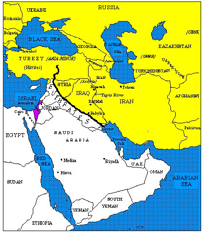
The Euphrates has an overall length of 2,780km (1,730miles), and is the longest river in the Middle East. 40% of is length is in Turkey, 25% in Syria and 35% in Iraq. It flows in a southwesterly direction across Turkey, crosses Syria in the east and continues across Iraq to the Arabian Gulf. It is fed by snowmelt from the mountains of Anatolia and by the waters of the Khabur and the Balikh River which join it in eastern Syria. It joins with the Tigris in southern Iraq to form the Shatt al Arab waterway. Before merging with the Tigris at Basra, the Euphrates divides into many channels and feeds the Iraqi marshlands. Like the Tigris, it is only navigable by very shallow-draft boats.
The upper Euphrates flows rapidly through deep canyons and narrow gorges in Anatolia. In 1990, Turkey built the Ataturk Dam, one of 21 dams planned on the Euphrates that will provide plenty of water for irrigation upstream; at the same time this huge diversion of water in Turkey has negative implications for Syria and Iraq which also rely on the river. The reservoir behind the Ataturk dam requires occasional one-month interruptions in the flow of the river for refilling.
The waters of the middle Euphrates are used to irrigate the plains of Syria, which depends on the Euphrates for over half its water needs. In 1973 al Thawra Dam was completed in northern Syria. The dam is 70m high, and created the 640 sq km Assad Reservoir which provides electrical power. The Tishrin Dam was completed in 2002. Syria has also dammed its two tributaries. Such projects are controversial, yet they fulfill the demands for water in the semi-arid country.
As it flows along the eastern edge of the Syrian Desert and into Iraq, the river loses speed, and Iraq receives a river with less water and high salt content. In northern Iraq the river is studded with islands, some with remains of old castles. Agriculture in Iraq, as in Syria, depends on the supply of water. Irregularities in flow make Iraqi agriculture vulnerable to drought. A dam at Haditha in west central Iraq was completed in 1986 to provide a water reserve for the country. Iraq has/had seven dams in operation.
The river’s average annual flow in Iraq is 32 billion cubic meters, and like the Tigris, its flow is very irregular: 53% of its waters flow during the three months from April to June.
Iraq, Syria and Turkey’s hydroelectric and irrigation projects were undertaken without any agreements of understanding between the three countries. There is a general understanding that requires the country upstream to not appropriate more than 50% of the flow measured at the point of entry to the country located downstream.
Other detrimental effects on the river include pollution from the dumping of untreated wastewater and aging and poorly maintained water and wastewater infrastructures. These are especially visible in Iraq which has seen over two decades of war.
The Euphrates and Tigris made possible the Mesopotamian civilization dating to 9000BC. Early farming communities introduced irrigation and built permanent dwellings near the river. Ancient cities located on or near the riverside include Babylon, Mari, Kish, Uruk, Ur and Eridu. For several centuries, the Euphrates formed the eastern limit of Roman control and defined the western regions of the Persian Empire. Major cities today include Raqqa and Deir al Zor in Syria and Karbala and Najaf in Iraq.
References: The Columbia Encyclopedia, Sixth Edition; European Institute for Research on Mediterranean and Euro-Arab Cooperation http://www.medea.be/