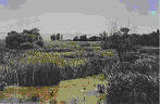
Ammiq is the only remaining freshwater wetland ecosystem in Lebanon. It lies at an altitude of 865 m on the western side of the Beqaa Valley, 35 km southeast of Beirut. The wetland and the surrounding estate lie on one of the most important bird migratory routes on the east of the Mediterranean Sea.
The swamp is fed by al Rhabe stream which rises in the foothills of Jebel Barouk in the Lebanon Mountains. It is bordered to the south by the channelized Nahr al Riachi stream and to the north by the Houjier River. The al Rhabe and Nahr al Riachi streams flow into the Houjier River which almost immediately joins the Litani River to the east.
Snow-melt from the nearby mountains raises the water level in spring. The swamp is usually inundated in late December or early January, and flooding reaches its maximum in March and April. The water level then falls throughout the summer, and the wetland usually dries up completely between August and November.
The site is a major water resource for the local farming community and large flocks of goats and sheep are moved into the swamp for grazing during the dry period of August-November. Other main land-uses are hunting (hunters come from all over Lebanon especially between autumn and spring), tourism and recreation.
Ammiq is a remnant of the swamps, lakes and seasonally flooded marshes which until 1911 covered 90% of the Beqaa Valley.
There are extensive reed beds, interspersed with open fields of coarse pasture, and trees along the Litani and Riachi rivers. The wetland is unprotected and under threat from drainage schemes, pollution from agricultural activities, hunting, overgrazing and indiscriminate shooting of migratory birds.