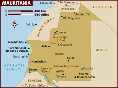
Location: northwestern Africa, bordering the North Atlantic Ocean, between Senegal and Western Sahara
Capital: Nouakchott
Area: 1,030,700 sq km
Coastline: 754 km
Elevation extremes
lowest point: Sebkha de Ndrhamcha -5 m
highest point: Kediet Ijill 915 m
Administrative divisions: 12 regions and one capital district: Tiris Zemmour,
Adrar , Hodh ech Chargui , Tagant, Hodh el Gharbi, Dakhlet Nouadhibou , Inchiri,
Trarza , Brakna , Gorgol, Guidimaka, Nouakchott Area
Official language: Arabic
National languages: Wolof, Pulaar, Fulfulde, Soninke, Hassaniya, French.
Religion: Islam
Population: 3,069,000
Age structure: 0-14 years: 46%
15-64 years: 52%
65 years and over: 2%
Life expectancy: total population: 70.61 years
male: 59 years
female: 60 years (2002 est.)
Literacy: total population: 51.2 %(2000)
male: 59.5%
female: 43.4%
Internet domain: .mr
Currency: Ouguiya
-----------------------------------------------------------------------------
1- Location
2- Terrain, Geography
3- Climate
4- Nature, Environment
5- People
6- Education
7- Arts and culture
8- Music
9- Religion
9- Economy
10- History
11- Constitution
12- Human Rights
13- Tourism
-----------------------------------------------------------------------------
1- Location:
Mauritania lies in northwestern Africa, bordered by the Atlantic Ocean and the Western Sahara to the west, Senegal to the south-west, Mali to the east and south-east, and Algeria to the north-east. The capital and largest city is Nouakchott. Its Atlantic Ocean coastline extends for 754km from the delta of the Sénégal River northward to the Cap Blanc Peninsula. It has an area of 1,030,700 sq km and a population of 3,069,000.
Mauritania is divided into 12 regions and one capital district, which in turn are subdivided into 44 departments.
2- Terrain, Geography:
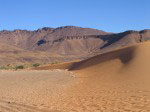
There are three distinct geographic regions in Mauritania: a narrow belt along the Sénégal River valley in the south; north of this valley, a broad east-west savannah characterized by vast sand plains and fixed dunes held in place by sparse grass and scrub trees; and a large northern arid region that merges into of the Sahara Desert. There are shifting sand dunes, rock outcroppings, and rugged mountainous plateaus that in a few places reach elevations of more than 500 m (1,640 ft). The high point, Mount Ijill at about 915 m (3,002 ft), is near Fdérik. The country generally is flat desert or semidesert.
The plateaus are cut by wadis (dry riverbeds), where the occasional floodwaters disappear into the few permanent drainage basins called guelt.
To the west, between the ocean and the plateaus, are alternating areas of plains (regs) and sand dunes (ergs), some of which are shifted from place to place by high winds. The dunes generally increase in size and mobility toward the north.
The sand varies in color and composition: fixed sand dunes are composed of coarse, brown sand, while shifting dunes consist of fine, reddish-colored sand that can be carried by the wind. Plateaus generally are covered with heavier blue, gray, and black sands that form a crusty surface over layers of soft, loose sand.
3- Climate
The climate is hot, dry and dusty, with temperatures around 40C but slightly more moderate along the coast. Nights can get freezing cold in the desert. In the valley of the Sénégal River where most of the crops are grown, 6-7 months of the year are hot.
The rainy season is short (hivernage), from July to September, with average annual precipitation from 500 to 600 millimeters in the far south, 0 to 100 millimeters in the northern two-thirds of the country. The duration of the rainy season diminishes progressively from south to north. Because of opposition between the wet southwesterlies and the hot dry desert wind (the harmattan), rains often come in stormy showers or squalls
4- Nature environment
Mauritania has four distinct ecological regions: the Saharan zone, the Sahelian zone, the Sénégal River Valley, and the Coastal zone.
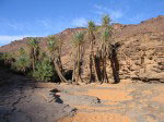
The Saharan zone makes up the northern two-thirds of the country. Some mountainous areas with a water source support small-leafed and spiny plants and scrub grasses suitable for camels. After a rain, dunes often sprout sparse vegetation that grows from the seeds of dormant desert plants. Cultivation is limited to oases, where date palms are used to shade other crops from the sun.
Rain usually falls between July and September. Often, isolated storms drop large amounts of water in short periods of time. Sometimes several years may pass without any rain.
Towns of the Sahara: Chinguetti, Ouadane, Fdérik.
The Sahelian zone extends south of the Saharan zone to within approximately thirty kilometers of the Sénégal River. In the northern Sahel, dunes are covered with scrub grasses and spiny acacia trees. Herds of cattle, sheep, and goats graze there. Farther south there is greater rainfall and more vegetation. Large date palm plantations are found on the Tagant Plateau, and savanna grasses, brushwood, and balsam cover fixed dunes. Occasional baobab and palmyra palm trees dot the savanna grasslands of the southern Sahel. The steppes in the south-central Sahel are frequented by gazelle, ostrich, warthog, panther, hyena and lynx. Crocodiles are found in the permanent streams.
By the late 1980s, desertification in the Sahelian zone drove people southward toward the Sénégal River valley.
The Sénégal River is the only permanent river between southern Morocco and central Sénégal. Before the droughts of the 1960s, 1970s, and 1980s, the fertile river valley ranged from sixteen to thirty kilometers north of the river. By the late 1980s, desertification had reached the northern bank of the river. Almost all of the valley's population engages in agriculture or fishing along the River and its main tributaries--the Karakoro, the Gorgol, and the Garfa. This area supplies most of the country's agricultural production.
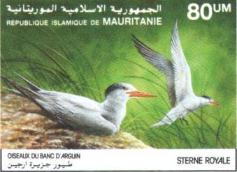
Ocean winds produce a humid but temperate climate along the coastal zone. High surf and shifting sand banks characterize the entire length of the shoreline. The Ras Nouadhibou (Cap Blanc) peninsula, which forms Dakhlet Nouadhibou (formerly Lévrier Bay) to the east, is one of the largest natural harbors on the west coast of Africa. Fifty kilometers southeast of Ras Nouadhibou is Arguin, and the Banc d’Arguin National Park.
By the late 1980s, the constant westward advance of sand dunes was threatening to cover wells, villages, and roads. The government secured international help to stabilize the dune field around Nouakchott, and planted 250,000 palm trees to create a barrier against the desert.
5-People
The majority of the population is Maures, of mixed Arab-Berber and Sudanic black descent.
The other ethnic groups are black African.
The Arab-Berber Maure population is composed of peoples of North African origins, who speak various dialects of Hassaniya Arabic. This dialect is derived from the Bedouin Arabic spoken by the Bani Hassan tribe, who extended their authority over most of the Mauritanian Sahara between the fifteenth and seventeenth centuries. It uses a vocabulary of both Arabic and Berber words. Most of the members of the aristocratic castes also know literary Arabic. The Maure population is concentrated in the north of the country, most are nomadic or semi-nomadic.
Multiracism is provided by groups of African ancestry: Tukulor (Toucouleur), who live in the Sénégal River valley; Pulaar and Fulani, who are dispersed throughout the south; Soninke (Sarakole), in the extreme south; and Wolof (Oulof), in coastal southwestern Mauritania, and the Bambara. Each of the ethnic groups retains its own language.
Maure society traditionally is hierarchical divided. At the head of the socioeconomic structure were the noble castes, composed Arab warriors, and Berber marabouts, scholars of the Qur'an who perform the functions traditionally associated with Islam. The bulk of the of the white Maure population were vassals who received protection from the warriors or marabouts in return for tribute.
6-Education
Islamic education is an important part of life in the nomadic communities and in settled villages in Mauritania. Both boys and girls receive traditional education in the local Qur'anic schools operated by the marabouts. Centers of advanced Islamic learning developed wherever a renowned marabout lived and taught. In these centers, students learned grammar and logic, as well as traditional religious subjects. Many of the centers developed and still hold sizable collections of rare and important manuscripts.
The French colonial administration established French public schools in the sedentary communities in the Senegal River Valley. They established a teacher training school at Boutilimit in 1950, and secondary school in Rosso also began training teachers in 1957. Another teacher training school was opened in Nouakchott in 1964.
French public schools were concentrated in the south, and black Africans enrolled in large numbers. As a result, blacks became the better educated and held most technical, professional, and diplomatic posts at the time of independence.
The Institute of Islamic Studies was founded in 1955 at Boutilimit and provided instruction in traditional Islamic subjects and teaching methods. It was relocated to Nouakchott in 1960, where it continued to draw upon the manuscript collection built by the marabouts of Boutilimit as well as other libraries of traditional Islamic literature in Chinguetti, Kaédi, Mederdra, Oualata (Walata), and Tidjikdja.
In the early 1980s, instruction in Pulaar, Azayr (Soninké), and Wolof was introduced into the primary school curriculum, and Arabic was emphasized at all levels.
School attendance is compulsory to age 14, but only a small minority of children benefit from it. By 1985, only 35 percent of primary-school-age children were enrolled in school, but only about 4 to 10 percent of secondary-school-age children were enrolled.
The independent government viewed secular education as a necessary step toward the development of a modern economy and as one of the main elements in promoting national unity. In the 1986 it created the State Secretariat of Culture, Information, and Telecommunications to launch a literacy campaign. In 1987, with assistance form the World Bank, Mauritania's education system was able to dedicate special attention to vocational training in important national industries, such as water engineering and fisheries.
The University of Nouakchott (1981) has faculties of letters and human sciences and of law and economics. The Institut Mauritanien de Recherche Scientifique (IRMS), and the national library are in the capital, and there are traditional local libraries in other urban centers.
7- Arts and crafts
Artistic activity in Mauritania following colonial times has centered on strong craft traditions. Goldsmithing is a fine art. Metalwork objects produced are daggers, anklets, bracelets, caskets, chests, teapots. Carved wood and silver chests are made in Mederdra.
Weaving techniques are similar to those in southern Morocco. Carpets, cushions, brightly colored rugs are made of camel or goat hair. In the south there are wood carving traditions.
In the early 1960s the government created the Bureau de l’Artisanat to help commercialize the crafts as a means of income to the craftsmen.
The Festival des Musiques Nomades takes place annually in Nouakchott .
8- Music
The term griot is 17th century French rendering of a local West African term: (Arabic iggiw, Wolof gewel, Fulfulde gawlo, Soninke jaare) that refers to an artisan class of hereditary professional musicians who hand down their skills from father to son. They have an original musical tradition with Arab-Berber and western Sudanic influences. Certain instruments are exclusive to griots.
Traditionally the griots were attendants to noble warriors. They defended the honor of their patrons, and their music and poetry were highly regarded forms of entertainment.
Griots functioned as musicians, historians, genealogists of their societies.
9-Religion
Mauritania has been an Islamic republic since independence in 1960. The Constitutional Charter of 1985 declares Islam the state religion and sharia the law of the land. Mauritanians are predominantly Sunni Muslims. They adhere to the Maliki rite, one of the four Sunni schools of law.
Most Maures belong to the Qadiriyaorder. The Tukulor and some of the Tagant tribes belong to the Tijaniya order. Many tariqas (mystical sects) flow from these orders.
Islam first spread southward into western Africa with the movement of Muslim traders and craftsmen, and later with the founders of Islamic brotherhoods. By the nineteenth century religious orders or brotherhoods attempted to make religion a force for expanding identities and loyalties beyond the limits of kinship. In recent decades, these orders have opposed tribalism and have been an indispensable element in the growth of nationalist sentiment.
Marabout is a general title that applies to any religious leader or to any person who performs the functions traditionally associated with Islam. They are usually are associated with a brotherhood and, like the leaders of the brotherhoods, are believed to possess baraka.
The functions of a marabout include teaching and promoting Islamic culture; leading religious recitations (including chants in some cases) in community prayer; and performing rites connected with curing the ill, preventing misfortune, and soothsaying. Because illness is believed to have spiritual as well as physiological causes, the marabout is called upon to help cure the sick. The marabout also makes, uses, and sells amulets and talismans that are believed to have mystical powers to protect their bearer from sickness, injury, and other misfortune.
Other functions of the marabout include negotiation, mediation, and activities related to peacekeeping; the granting of protection and asylum to individuals; and the acting as advisers and agents of important tribal leaders.
10-Economy
Mining
Iron mining began by a European consortium, Miferma, in 1963 . The company was nationalized in 1974 and was renamed Cominor (Complexe Minier du Nord). The iron ore deposits of Mount Ijill have nearly been exhausted, and exploitation of reserves at Guelbs began in 1984.
Exploitation of copper deposits in Akjoujt was started by a US-European consortium, Somima (Société Minière de Mauritanie), in 1969. Somima was nationalized in 1975.
Prospecting for tungsten, petroleum, uranium and iron is carried out be a state-owned company which was opened to private investment in 1978. Titanium and phosphate reserves have been identified. There are substantial gypsum deposits near Nouakchott; most of the annual production is exported to Senegal.
Agriculture
Agriculture employs two-thirds of the work force. Millet sorghum, beans, yams, corn (maize), and cotton, and watermelons are grown along the Senegal River, dates are grown in oases.
In agriculture the aim of successive Mauritanian governments has been to increase the amount of irrigated land in the Sénégal River valley and to increase the production of rice. Between the years of 1981 and 1983 a 45 metre high arch dam was constructed at the Gorgol-Noir, a tributary of the Sénégal River, to help improve the irrigation situation.
Fishing
Mauritania’s waters among richest in world. The most valuable varieties of fish in its Atlantic waters are cod, sole, octopus, squid, lobster, and shrimp.
In 1979 Mauritania initiated its New Fisheries Policy and established a 200-nautical-mile Exclusive Economic Zone. The New Fisheries Policy had three objectives: the formation of Mauritanian-controlled joint ventures, the creation of a national fishing fleet, and the establishment of a Mauritanian-controlled fish processing industry at Nouadhibou where fish are canned, frozen, or processed as fish flour. Several tons each year are dried and exported to other African countries.
In 1986, estimates of the country's potential annual marine resources ranged between 400,000 and 700,000 tons.
Mauritanians historically had done little fishing. The majority Maure population consumed little fish, and only the small Imraguen ethnic group fished for subsistence.
11-History
Approved by referendum in July 1991.
13-Human Rights
Slavery is illegal and was abolished by law in 1981; efforts to eliminate the vestiges and consequences of slavery, goals to which both the government and major opposition parties are committed have begun to bear fruit. Several Mauritanian non-governmental organizations including SOS Esclaves, and Association Mauritanienne des Droits de l’Homme (AMDH), were officially legalized by the authorities in June 2005. They and other organizations had been classified as illegal and had operated with great difficulty in Mauritania.
Slavery-related practices persisted most strongly in the east and southeast, where education levels were generally lower and there was a greater need for manual labor in work such as herding livestock and tending fields.
Women
The constitution of Mauritania guarantees equality before the law and full rights of political participation for women, Article 10 [Individual Freedom, Rule of Law]. Women have legal rights to property and child custody, and, among the more modern and urbanized population, these rights are recognized.
The law provides that men and women receive equal pay for equal work. While not universally applied in practice, the civil service and the state mining company, observed this law. In the modern wage sector, women receive family benefits, including 3 months of maternity leave.
In 1987, President Taya named three women to cabinet-level posts to "correct countless managerial mistakes committed in the past." Khadijatou Bint Ahmed of Boutilimit was appointed minister of mines and industries. Lalla Mariam Bint Moulaye was appointed associate director of the presidential cabinet, and N'Deye Tabar Fall became general secretary of the Ministry of Health and Social Affairs.
Female genital mutilation is practiced among all ethnic groups, often performed on the 7th day after birth. The Government and international organizations developed campaigns that focus on eradicating the practice of FGM in hospitals and by midwives, and educating the populations on the health risks of the practice. The High Islamic Council of Mauritania, the Islamic Scholar Association, and the National Forum for Women's Rights launched campaigns that emphasized that FGM is not a religious requirement.
The Secretariat for Women's Affairs the government, women’s groups national and international NGO’s organize seminars and workshops regularly to publicize women's rights and improve the status of women.
Healthcare
There is only one major modern hospital in Nouakchott and 25 other regional health centers. Free medical services are available to the poor. Traditional medicine flourishes. Though Mauritania ranks among the world’s thirty poorest countries, its social welfare system, the National Social Insurance Fund, provides disability payments for industrial accidents and occupational diseases, maternity benefits and old-age pensions.
14-Tourism:
Mauritania is a favorite destination for adventurers: amateur astronomers study the skies, students of history can leaf through 1000-year-old books, archaeologists dig for past civilization, and fishermen enjoy the sandy beaches and warm sun. It is a destination for car racing, gliding, and parasailing.
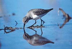
Banc d’Arguin National Park is one of the world’s best places for birdwatching. It was inscribed as a UNESCO World Heritage Site in 1989.
References:
The Dictionary of Art, 1996. v 20 p 861-862.
The New Grove Dictionary of Music and Musicians, 2001. Second edition, v10, p427.
The New Encyclopaedia Britannica, Micropaedia, 2007. Fifteenth edition, v 7, p957.
Ethnologue http://www.ethnologue.com/show_country.asp?name=Mauritania
U.S. Library of Congress http://countrystudies.us/mauritania/
Amnesty International http://www.amnestyusa.org/Mauritania/
Islam Online http://www.islamonline.net/english/ArtCulture/2005/05/article04.shtml#11
African Bird Club http://www.africanbirdclub.org/countries/Mauritania/introduction.html